Friday, December 31, 2010
Thursday, December 30, 2010
H2Oasis
A few weekends ago (before we went home to Georgia for the holidays), we spent a Sunday afternoon at H2Oasis (#14 on our list), the indoor water park near our house. We went with another couple and we had a fun time. The entry fee was steep at $25 per person. They had 2 large water slides, a wave pool, a hot tub, a lazy river and a small ship that is meant for young children (under 10). My favorite part was the hot tub. Steven mainly liked the big water slide. It has some parts of the ride that are completely dark!
All in all, we had a good time, however, the price will prevent us from going back again. Also, we lost interest after about 2 hours. If we had young children, then they would really enjoy it!
Rebekah
All in all, we had a good time, however, the price will prevent us from going back again. Also, we lost interest after about 2 hours. If we had young children, then they would really enjoy it!
Rebekah
Sunday, November 21, 2010
The Haul Road
In early September I started to get anxious. It was getting very late in the summer, but there was one trip I definitely wanted to do before it ended. We decided to take off Thursday, Friday, and Monday around the last weekend in September to drive the Haul Road.
The Haul Road, also known as the Dalton Highway (#84 on the list), is 414 miles long and stretches from just north of Fairbanks to Deadhorse, Alaska along the Arctic Ocean. The road was built along the Trans Alaska Pipeline and was used by workers to build the massive project. Now it is mainly used as a trucking road to transport goods to Prudhoe Bay (where they drill for oil). This is also the road driven on for the History Channel show Ice Road Truckers.

Since we were leaving so late in the season we had to be even more prepared for the cold weather and possible snow. The road is 80% gravel, has many steep grades, and has the longest stretch of road without service in the United States (240 miles between Coldfoot and Deadhorse). After reading about the drive online we packed extra food and water, warm weather gear, 2 full size spare tires (purchased the new tires and wheels), 5 gallons of extra gas (purchased the spare gas container), and a CB Radio to communicate with the truckers (purchased and installed myself).

We left Wednesday evening and drove a couple of hundred miles to just north of Denali National Park. The next morning we woke up to 26 degree weather. After shaking off the cold we continued along our way, made a short stop for breakfast and gas in Fairbanks, and quickly made it to the start of the highway.
Now in the past month we had driven on the Denali Park Road, the Denali Highway, and the McCarthy Road. After reading on line about the Dalton Highway I figured it would be the worst road we had driven on in Alaska. I also figured (like most typical roads) the first part would be the 20% that is paved and the gravel road would arrive as we got farther away from civilization.

Wrong on both accounts. The Dalton Highway was the nicest of the gravel roads we drove on in Alaska. Are there potholes and is it possible to get flat tires? Definitely. But the biggest problem with the road is that it is very remote. Since 18 wheelers are constantly driving this road year-round, the Department of Transportation maintains the road very well. We saw several water trucks and graders working the road as we made our way through. The speed limit is 50 MPH for the entire drive and we were able to go at least that fast. And the paved parts are strategically placed by the DOT in spots with the sharpest turns and most difficult terrain.

There was even a bustling intersection with a traffic light.

About 60 miles along the way we made it to the famous Yukon River (new entry #120). We stopped briefly, but it was still quite cold outside (the water in puddles along the road was frozen solid) so we continued on pretty quick (this was a common theme throughout the trip).

An hour later we crossed the Arctic Circle (#119 on the list).

During this entire stretch of road we are driving between two National Wildlife Refuges, the Kanuti and the Yukon Flats (part of #121). I was not able to verify any of this, but I believe there were 4 national lands (these two and two others we will see later) that had their borders moved in order to build this road. Because this road goes between these four lands on about a 10 mile stretch of land that is just a little too convenient. Needless to say the views on both sides of the road were gorgeous.


An hour later (these first 3 destinations along the Dalton are very conveniently spaced apart) we arrived in the bustling town of Coldfoot (new entry #117). It consists of 1 hotel, 1 gas station, 1 restaurant, 1 bar, and 1 gift shop. All of them are owned by the same company and share 3 or 4 "buildings" which are really trailers. Pretty much every building along this road is made of these temporary buildings.

After gassing up we continued along our way. Starting now there are no services for 240 miles.

About 70 miles north of Coldfoot we came across a van that had just pulled off with a flat tire. Not wanting to be caught in that situation our self, we decided to pull of the road and help the poor folks. In the van were 2 gentlemen from the Czech Republic who were working for a year at a resort in Canada. They had purchased the old van from another worker there and had decided to attempt the trip.
They did not have any full size spare tires. Instead they had 1 miniature donut that was so rusted I was convinced it would have fallen apart from the weight of the vehicle. On top of that it was also flat. Since we had tires to spare, we offered our full size donut however it didn't line up and would not work.
About now the Czechs were beginning to freak out. They decided to try and flag down a passing trucker. I had read on several websites that truckers would not stop. They are on a tight schedule and coming to a complete stop and getting back up to speed wastes too much gas. A few minutes later we could hear the first truck approaching. One of the Czechs held up his hand to try and waive down the truck.
Sure enough, the trucker pulled over. He had a bunch of equipment in his cab so not only did he repair the flat tire and pump both the flat and the spare full of air, but he refused to take any money as payment. About 10 minutes after he stopped he sent the van back towards Coldfoot to get properly patched.
We got back on our way and shortly after passing the farthest north Spruce Tree along the Dalton Highway, we started rising up to Atigun Pass. This is the highest point along the highway, and is also a Continental Divide between the northern Arctic Ocean and the southern Pacific Ocean. This is the main spot we were worried would have snow on the road, but luckily it was just gravel the entire way.


Shortly after the pass the sun began to set so we pulled off for the night. The next morning we awoke to frost on the tundra and a frosty temperature of 16 degrees. As we continued driving we began dropping down and the terrain got flatter and flatter. The last 50 miles of land is completely flat with tundra and many small lakes dotting the terrain.

This flat terrain opened up the landscape and as we drove past the Arctic National Wildlife Refuge (part of #121) we began to see animals.
There were caribou...


We showered at one of the 3 hotels in town and then went to eat lunch at another.

After lunch we explored the town a little. It is very industrial and there are all kinds of weird vehicles and buildings. While they do get a few tourists, most of the town is working. Employees on the North Slope typically do 2 weeks on and 2 weeks off.


Since there wasn't very much to see or do in Deadhorse, we started heading south again early in the afternoon. We made it into Coldfoot for a late dinner and stayed to have a drink at the bar and relax after the 2 long days of driving.

Since it was so cold on the trip that was the only real hike that we did. We made it back to Anchorage that night. In just over 3 days we drove 1900 miles. It was a lot of driving, but was a very unique and interesting experience. There are very few places in the world (if anywhere else) to see and do the things we did on this trip. It is one of my favorite trips we have taken while in Alaska and we will not soon forget the experience.

Steven
The Haul Road, also known as the Dalton Highway (#84 on the list), is 414 miles long and stretches from just north of Fairbanks to Deadhorse, Alaska along the Arctic Ocean. The road was built along the Trans Alaska Pipeline and was used by workers to build the massive project. Now it is mainly used as a trucking road to transport goods to Prudhoe Bay (where they drill for oil). This is also the road driven on for the History Channel show Ice Road Truckers.

Since we were leaving so late in the season we had to be even more prepared for the cold weather and possible snow. The road is 80% gravel, has many steep grades, and has the longest stretch of road without service in the United States (240 miles between Coldfoot and Deadhorse). After reading about the drive online we packed extra food and water, warm weather gear, 2 full size spare tires (purchased the new tires and wheels), 5 gallons of extra gas (purchased the spare gas container), and a CB Radio to communicate with the truckers (purchased and installed myself).

We left Wednesday evening and drove a couple of hundred miles to just north of Denali National Park. The next morning we woke up to 26 degree weather. After shaking off the cold we continued along our way, made a short stop for breakfast and gas in Fairbanks, and quickly made it to the start of the highway.
Now in the past month we had driven on the Denali Park Road, the Denali Highway, and the McCarthy Road. After reading on line about the Dalton Highway I figured it would be the worst road we had driven on in Alaska. I also figured (like most typical roads) the first part would be the 20% that is paved and the gravel road would arrive as we got farther away from civilization.

Wrong on both accounts. The Dalton Highway was the nicest of the gravel roads we drove on in Alaska. Are there potholes and is it possible to get flat tires? Definitely. But the biggest problem with the road is that it is very remote. Since 18 wheelers are constantly driving this road year-round, the Department of Transportation maintains the road very well. We saw several water trucks and graders working the road as we made our way through. The speed limit is 50 MPH for the entire drive and we were able to go at least that fast. And the paved parts are strategically placed by the DOT in spots with the sharpest turns and most difficult terrain.

There was even a bustling intersection with a traffic light.

About 60 miles along the way we made it to the famous Yukon River (new entry #120). We stopped briefly, but it was still quite cold outside (the water in puddles along the road was frozen solid) so we continued on pretty quick (this was a common theme throughout the trip).

An hour later we crossed the Arctic Circle (#119 on the list).

During this entire stretch of road we are driving between two National Wildlife Refuges, the Kanuti and the Yukon Flats (part of #121). I was not able to verify any of this, but I believe there were 4 national lands (these two and two others we will see later) that had their borders moved in order to build this road. Because this road goes between these four lands on about a 10 mile stretch of land that is just a little too convenient. Needless to say the views on both sides of the road were gorgeous.


An hour later (these first 3 destinations along the Dalton are very conveniently spaced apart) we arrived in the bustling town of Coldfoot (new entry #117). It consists of 1 hotel, 1 gas station, 1 restaurant, 1 bar, and 1 gift shop. All of them are owned by the same company and share 3 or 4 "buildings" which are really trailers. Pretty much every building along this road is made of these temporary buildings.

After gassing up we continued along our way. Starting now there are no services for 240 miles.

About 70 miles north of Coldfoot we came across a van that had just pulled off with a flat tire. Not wanting to be caught in that situation our self, we decided to pull of the road and help the poor folks. In the van were 2 gentlemen from the Czech Republic who were working for a year at a resort in Canada. They had purchased the old van from another worker there and had decided to attempt the trip.
They did not have any full size spare tires. Instead they had 1 miniature donut that was so rusted I was convinced it would have fallen apart from the weight of the vehicle. On top of that it was also flat. Since we had tires to spare, we offered our full size donut however it didn't line up and would not work.
About now the Czechs were beginning to freak out. They decided to try and flag down a passing trucker. I had read on several websites that truckers would not stop. They are on a tight schedule and coming to a complete stop and getting back up to speed wastes too much gas. A few minutes later we could hear the first truck approaching. One of the Czechs held up his hand to try and waive down the truck.
Sure enough, the trucker pulled over. He had a bunch of equipment in his cab so not only did he repair the flat tire and pump both the flat and the spare full of air, but he refused to take any money as payment. About 10 minutes after he stopped he sent the van back towards Coldfoot to get properly patched.
We got back on our way and shortly after passing the farthest north Spruce Tree along the Dalton Highway, we started rising up to Atigun Pass. This is the highest point along the highway, and is also a Continental Divide between the northern Arctic Ocean and the southern Pacific Ocean. This is the main spot we were worried would have snow on the road, but luckily it was just gravel the entire way.


Shortly after the pass the sun began to set so we pulled off for the night. The next morning we awoke to frost on the tundra and a frosty temperature of 16 degrees. As we continued driving we began dropping down and the terrain got flatter and flatter. The last 50 miles of land is completely flat with tundra and many small lakes dotting the terrain.

This flat terrain opened up the landscape and as we drove past the Arctic National Wildlife Refuge (part of #121) we began to see animals.
There were caribou...

our first wild musk ox...

and the first fox we had seen in Alaska (part of #86).

Just before lunch time we made it into the town of Deadhorse (new entry #118). This town is much larger than Coldfoot and is the town attached to Prudhoe Bay. It is about 4 miles from the Arctic Ocean, but unfortunately Prudhoe Bay is gated off and in the way. During the summer there is a tour which operates to the ocean from Deadhorse, but the 1 guide that runs the tour left Deadhorse for the winter 3 weeks before we arrived.


We showered at one of the 3 hotels in town and then went to eat lunch at another.

After lunch we explored the town a little. It is very industrial and there are all kinds of weird vehicles and buildings. While they do get a few tourists, most of the town is working. Employees on the North Slope typically do 2 weeks on and 2 weeks off.


Since there wasn't very much to see or do in Deadhorse, we started heading south again early in the afternoon. We made it into Coldfoot for a late dinner and stayed to have a drink at the bar and relax after the 2 long days of driving.
The next morning was 15 degrees. We drove off the highway past Wiseman (the only town along the road that has a full-time, year round population down to a mining operation about 10 miles back. We bundled up and hiked down into the Gates of the Arctic National Park (#82). As we were hiking through the valley we walked along animal paths and kept seeing moose tracks. We knew they must be in the area, and sure enough saw a big bull moose about 1oo yards away just as we turned back.

Since it was so cold on the trip that was the only real hike that we did. We made it back to Anchorage that night. In just over 3 days we drove 1900 miles. It was a lot of driving, but was a very unique and interesting experience. There are very few places in the world (if anywhere else) to see and do the things we did on this trip. It is one of my favorite trips we have taken while in Alaska and we will not soon forget the experience.

Steven
Monday, November 1, 2010
Denali National Park
Every year, after the tourist season is over and the national park buses stop running, there is a lottery for the Denali Park Road. This year, the dates for the lottery were the 17th, 18th, 19th and 20th of September. There are only 400 passes given out for each day. With a lottery pass, you are able to drive your car into Denali Park and explore at your own pace without having to be on a bus. You can stop for wildlife viewing and hiking whenever you want! We actually ended up winning multiple passes, so we sold the extra ones on Craigslist. We went into the park on the 18th. We headed up that way on Friday night and we camped just outside the park gate at Riley Creek Campground. We slept in our tent although it was very cold, about 28 degrees! We had packed extra warm clothes to wear though, so we were nice and toasty in our fleece and our sleeping bags! You are able to get into the park bright and early on Saturday morning at 6am. We headed out of our campsite a little bit later than that though, around 7:30. As we headed into the park, it was a little bit cloudy and foggy.

There was lots of frost covering the branches and the tundra. This was disappointing because the whole week before, it had been clear, blue skies and very sunny. The weather report was calling for great weather though so we had high hopes for the day. It was a wonderful day because as the sun came up, the fog lifted and the blue skies shined through! As the sun came up, the temperature also warmed up nicely.

We got our very first glimpse of wildlife too! We spotted a lynx although it was very far away!

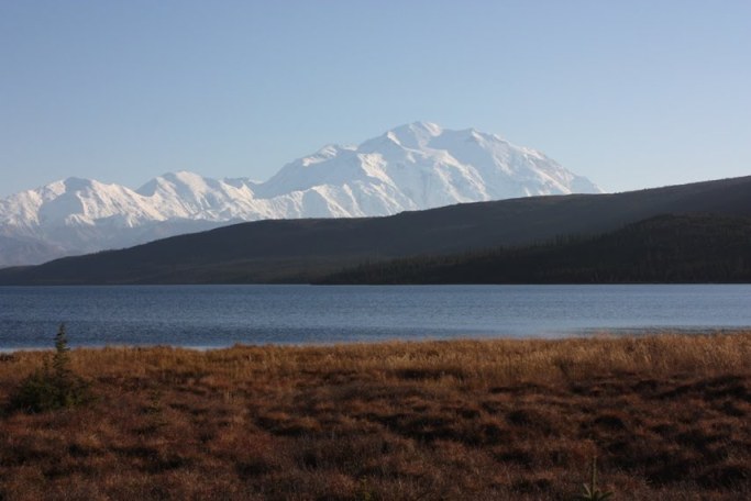
Just as the fog lifted, we rounded a sharp turn and caught sight of Denali waaaay off in the distance.

One of the great things about being on the road with other private vehicles is that when someone spots some wildlife, everyone pulls over to watch. So, when you see a whole bunch of cars just stopped, you know that there is something there that you want to see! This time, it was a family of 3 brown bears. They were frolicking and playing in the tall, dense bushes. Here is one of our bear friends that we photographed from a safe distance.

Here are some more photos of the lovely mountain, Mt. McKinley or Denali as many people call it.


We drove all the way to the Eielson visitor's center, made a sandwich and then kept on going to the end of the park road in Kantishna. There is not much out there except for a small cabin that was where some homesteaders lived many years ago and some small hotels, which were already closed down for the season.

We spent some time at Wonder Lake as well. The last time that we were here (in June), there were tons of bugs and mosquitoes.

Steven wanted to stay in the park for a while, so that he could get just the right picture when the sun was in a perfect spot in the sky. We played cards while enjoying the sunshine and I also picked some blueberries and cranberries (I still have some in the freezer)!

Here are some more pictures of Mt. McKinley from Wonder Lake.


Once we got our pictures, we started to head back as it was about 5-6pm and we were still all the way inside the park. We started to see many snowshoe hares. Their coloring had not yet changed to all white for the winter.

There was also a traffic jam due to a helicopter needing to land in the middle of the road to airlift someone out of the park and to Fairbanks or Anchorage because of a medical emergency. We aren't really sure what was wrong, but I hope everything turned out alright for them! I once read an article about many Alaskans buying Lifeflight insurance to help cover the costs of being airlifted out and taken to a hospital.

On the way out, we also saw four Dall sheep hanging out in the brush resting taking an evening nap.


Look how close they were to the road and to our car. That one walked right by my car door. If I had reached out, I could have touched his horn.
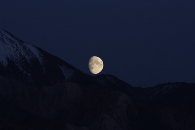
We stayed out pretty late because we were hoping to see the northern lights, which we still had not seen since living in Alaska. All we saw though was this almost full moon. It was very bright in the sky!

The next day, we wanted to drive down the Denali Highway (#116)just a little ways. This highway leading from Paxson to Cantwell was originally used as the access road to the national park before the Parks highway was built from Wasilla to Fairbanks. It is only open to travel during the summer months as it is not maintained during the winter. We saw some pretty views of the Alaska Range as well as a porcupine (part of #86). He was a little scared and quickly ran off into the bushes.


Rebekah

There was lots of frost covering the branches and the tundra. This was disappointing because the whole week before, it had been clear, blue skies and very sunny. The weather report was calling for great weather though so we had high hopes for the day. It was a wonderful day because as the sun came up, the fog lifted and the blue skies shined through! As the sun came up, the temperature also warmed up nicely.

We got our very first glimpse of wildlife too! We spotted a lynx although it was very far away!

Just as the fog lifted, we rounded a sharp turn and caught sight of Denali waaaay off in the distance.

One of the great things about being on the road with other private vehicles is that when someone spots some wildlife, everyone pulls over to watch. So, when you see a whole bunch of cars just stopped, you know that there is something there that you want to see! This time, it was a family of 3 brown bears. They were frolicking and playing in the tall, dense bushes. Here is one of our bear friends that we photographed from a safe distance.

Here are some more photos of the lovely mountain, Mt. McKinley or Denali as many people call it.


We drove all the way to the Eielson visitor's center, made a sandwich and then kept on going to the end of the park road in Kantishna. There is not much out there except for a small cabin that was where some homesteaders lived many years ago and some small hotels, which were already closed down for the season.

We spent some time at Wonder Lake as well. The last time that we were here (in June), there were tons of bugs and mosquitoes.

Steven wanted to stay in the park for a while, so that he could get just the right picture when the sun was in a perfect spot in the sky. We played cards while enjoying the sunshine and I also picked some blueberries and cranberries (I still have some in the freezer)!

Here are some more pictures of Mt. McKinley from Wonder Lake.

Once we got our pictures, we started to head back as it was about 5-6pm and we were still all the way inside the park. We started to see many snowshoe hares. Their coloring had not yet changed to all white for the winter.

There was also a traffic jam due to a helicopter needing to land in the middle of the road to airlift someone out of the park and to Fairbanks or Anchorage because of a medical emergency. We aren't really sure what was wrong, but I hope everything turned out alright for them! I once read an article about many Alaskans buying Lifeflight insurance to help cover the costs of being airlifted out and taken to a hospital.

On the way out, we also saw four Dall sheep hanging out in the brush resting taking an evening nap.


Look how close they were to the road and to our car. That one walked right by my car door. If I had reached out, I could have touched his horn.
We stayed out pretty late because we were hoping to see the northern lights, which we still had not seen since living in Alaska. All we saw though was this almost full moon. It was very bright in the sky!
The next day, we wanted to drive down the Denali Highway (#116)just a little ways. This highway leading from Paxson to Cantwell was originally used as the access road to the national park before the Parks highway was built from Wasilla to Fairbanks. It is only open to travel during the summer months as it is not maintained during the winter. We saw some pretty views of the Alaska Range as well as a porcupine (part of #86). He was a little scared and quickly ran off into the bushes.


Rebekah
Sunday, October 3, 2010
Wrangell-St. Elias National Park
On Labor Day Weekend we decided to finally make the long drive to Wrangell-St. Elias National Park (#60 on the list). It is the largest National Park in the country, but there are only two roads that go into the park - the McCarthy Road and the Nabesna Road. They are both poorly maintained dirt roads, but we decided to take the 60 mile McCarthy Road.

Afterward we got back on the highway and soon began the slow, bumpy drive along the McCarthy Road. The National Park Service recommends 3 hours to complete the 60 miles. Early on we got to see the sun rising over the Copper River (famous for its tasty Red Salmon)

We managed to complete it in around 2.5, but this is probably the worst road we have driven on in Alaska. There were even some narrow 1 lane bridges over river gorges.

After 60 miles the road just ends. There is a campsite and a couple of bed and breakfasts, but not much else. In order to get to Kennecott and McCarthy you have to cross a long foot bridge over the river that is fed from the Kennicott and Root glaciers.

From there you can either pay to take a shuttle or you can walk the .5 miles to McCarthy or 4.5 to Kennecott. Since we were going to Kennecott first we decided to pay the $10 each for the shuttle. Kennecott was a copper mining town run by the Kennecott Copper Corporation which started operations in 1903. By the time they were done, this proved to be the richest and purest concentration of copper in the world.

We toured the picturesque town along the edge of the valley.


When the town was created, they did not know they were in a valley. The Kennicott Glacier filled the valley completely. It has now receded greatly, but you can still see it in the valley. Most of what you see now is the terminal moraine, which is where all of the dirt, gravel, and rocks the glacier pushes with it are deposited. Under those hills of dirt and rock (which are not man made) is still ice. The Kennicott Glacier moved back to the left, while the smaller Root Glacier moved back to the right.

We even got to tour inside the building, including the mill where they did all of the sorting, crushing, and other processes. The technology here was very advanced for the day.

That evening we went into McCarthy to the bar (yes, there is only one bar). Everyone gathers at the bar in the evening. From the tour company guides, to people you went on tours with, to the few people that live and own land/businesses in McCarthy - everyone was there. This weekend was their final operating weekend so they brought in a live band! (exciting, huh?). McCarthy was created originally as a town to support the Kennecott Mine. Kennecott was a dry town and only workers as well as upper management's families were allowed to stay in Kennecott.
The next day we had scheduled a rafting trip, so naturally it was the only day of the weekend that was wet and very cold. We went with Copper Oar Rafting and the trip was very well done. They had some wet and warm gear for us and then we loaded into the boat. Now I was expecting we would have to row (and with how cold it was I was actually looking forward to having to move), but the guide is the only one to row. There were only 4 of us going, but since we were going to the middle of nowhere the company had to take 2 rafts for safety. We put in just South of the footbridge on the Kennicott River. From there we floated into the Nizina River and into the Nizina Canyon. Once we were in the canyon, and safely out of the wind, we stopped for lunch along the banks. The lunch was actually very nice as we had hot chocolate and sandwiches. They put up a tarp so we could be out of the rain and had portable tables (complete with tablecloths) and chairs.
After warming up and eating more than enough food we continued on our journey through the canyon. Later that afternoon we met the Chitina River and pulled ashore at a little grass airstrip. Since we had floated in the middle of nowhere to the middle of nowhere the only way to get back to somewhere was to fly back. So, the rafting company had arranged for the local pilot to pick us up. I did not take any pictures on the rafting trip because of the rain, but I did get a few pictures from the small plan on the way back. Typically they take the scenic route back over the Root Glacier and the 7,000 foot Stairway Icefall (basically a very steep part of the glacier as it comes down from the tall mountains of the Wrangell Range), but due to the weather and bad visibility we did not get that part of the trip.

That evening after dinner we were still a little cold. And our tent was still wet from the rain the night before.

Even though it had stopped raining already (and actually turned into a very nice Labor Day Monday), we decided to make the long drive back to Anchorage that night. We arrived just after 2 am and spent Monday resting and relaxing.
 (a police officer rolled up to us as were taking this picture wondering what we were possibly doing)
Steven
We left right after work on Friday and drove past Glenallen as far as we could until it got dark. We decided to stop and camp at Liberty Falls State Recreation Area (new entry #114). That night was very clear and the stars were very bright and amazing. The next morning we woke up early and completed the short hike to the waterfall.

Afterward we got back on the highway and soon began the slow, bumpy drive along the McCarthy Road. The National Park Service recommends 3 hours to complete the 60 miles. Early on we got to see the sun rising over the Copper River (famous for its tasty Red Salmon)

We managed to complete it in around 2.5, but this is probably the worst road we have driven on in Alaska. There were even some narrow 1 lane bridges over river gorges.

After 60 miles the road just ends. There is a campsite and a couple of bed and breakfasts, but not much else. In order to get to Kennecott and McCarthy you have to cross a long foot bridge over the river that is fed from the Kennicott and Root glaciers.

From there you can either pay to take a shuttle or you can walk the .5 miles to McCarthy or 4.5 to Kennecott. Since we were going to Kennecott first we decided to pay the $10 each for the shuttle. Kennecott was a copper mining town run by the Kennecott Copper Corporation which started operations in 1903. By the time they were done, this proved to be the richest and purest concentration of copper in the world.

We toured the picturesque town along the edge of the valley.


When the town was created, they did not know they were in a valley. The Kennicott Glacier filled the valley completely. It has now receded greatly, but you can still see it in the valley. Most of what you see now is the terminal moraine, which is where all of the dirt, gravel, and rocks the glacier pushes with it are deposited. Under those hills of dirt and rock (which are not man made) is still ice. The Kennicott Glacier moved back to the left, while the smaller Root Glacier moved back to the right.

We even got to tour inside the building, including the mill where they did all of the sorting, crushing, and other processes. The technology here was very advanced for the day.

That evening we went into McCarthy to the bar (yes, there is only one bar). Everyone gathers at the bar in the evening. From the tour company guides, to people you went on tours with, to the few people that live and own land/businesses in McCarthy - everyone was there. This weekend was their final operating weekend so they brought in a live band! (exciting, huh?). McCarthy was created originally as a town to support the Kennecott Mine. Kennecott was a dry town and only workers as well as upper management's families were allowed to stay in Kennecott.
The next day we had scheduled a rafting trip, so naturally it was the only day of the weekend that was wet and very cold. We went with Copper Oar Rafting and the trip was very well done. They had some wet and warm gear for us and then we loaded into the boat. Now I was expecting we would have to row (and with how cold it was I was actually looking forward to having to move), but the guide is the only one to row. There were only 4 of us going, but since we were going to the middle of nowhere the company had to take 2 rafts for safety. We put in just South of the footbridge on the Kennicott River. From there we floated into the Nizina River and into the Nizina Canyon. Once we were in the canyon, and safely out of the wind, we stopped for lunch along the banks. The lunch was actually very nice as we had hot chocolate and sandwiches. They put up a tarp so we could be out of the rain and had portable tables (complete with tablecloths) and chairs.
After warming up and eating more than enough food we continued on our journey through the canyon. Later that afternoon we met the Chitina River and pulled ashore at a little grass airstrip. Since we had floated in the middle of nowhere to the middle of nowhere the only way to get back to somewhere was to fly back. So, the rafting company had arranged for the local pilot to pick us up. I did not take any pictures on the rafting trip because of the rain, but I did get a few pictures from the small plan on the way back. Typically they take the scenic route back over the Root Glacier and the 7,000 foot Stairway Icefall (basically a very steep part of the glacier as it comes down from the tall mountains of the Wrangell Range), but due to the weather and bad visibility we did not get that part of the trip.

That evening after dinner we were still a little cold. And our tent was still wet from the rain the night before.

Even though it had stopped raining already (and actually turned into a very nice Labor Day Monday), we decided to make the long drive back to Anchorage that night. We arrived just after 2 am and spent Monday resting and relaxing.
 (a police officer rolled up to us as were taking this picture wondering what we were possibly doing)
Steven
Subscribe to:
Posts (Atom)